Wednesday 19 December 2012

Wednesday 12 December 2012

Downtime 11th December

Apologies for the whole day without updates.
Virgin Broadband had "A Nationwide fault affecting some customers"
Although the router appeared to be synchronising correctly, there was no service from early hours of 11th until about 4am on the 12th.
Things were a little slow for a while after reconnection, with some pages not updating, but it seems all is well now.
No data was lost, it only affected the online pages until everything was updated the following day.

To be fair I can only remember one other period of half day or so when the broadband service failed, although we have had broken phone line incidents which took several days to fix.

Wednesday 5 December 2012

Today's snow

A short video from around 1pm when the showers were really getting going.
Will it last for weeks like in December 2010?
Probably not but it will be on the cold side right through until Christmas by the sound of it.
Tomorrow will see some thawing then the weekend is cold but drier.

Sunday 2 December 2012

Weather computer up-time

Must mention the little Samsung NC10 Netbook has been rebooted for the first time since April 18th and was still running Weather-Display flawlessly.
However there was a long list of Windows 7 updates waiting so I've done them - which required restart -  and I see more have appeared so may install those too then try for another record run!
The 'packets received' from the VP2 - since last program restart - was on about 9,500,000. (Nine and a half million)
The WD software has also been updated to the latest version..

Edit: at 5th December all important Windows Updates have been applied (145mb!) - so we are good to go for a long stretch.
I did a full backup just in case, but so far all seems to be running smoothly.

Thursday 29 November 2012

November wet spell

The first half of November was relatively dry, but the final week made up for it with 100.4mm between the 24th and 29th.
The month's total at 29th November stands at 148mm which is well above the average 105mm but well behind 2009 which clocked up 181mm.

So a wet month but locally the Esk flow,  though very high at times in the last week was not exceptional indeed it was probably similar to during the wet spell in September (when we had about 70mm over two days).

Further afield the Ouse through York also seems to have peaked at similar concerning but not record breaking levels, while at Malton the Derwent has been higher than any time since new defences were completed. Flooding there was mainly the result of surface water accumulating faster than it could be pumped (up) into the flooded river and on balance the new works must be declared a success although a few property owners may dispute this.

The cause was a classic for serious rain events over the NE of England, with a slow-moving Low Pressure system in the southern North Sea throwing almost continuous rain towards the east coast.
With 'Orographic Enhancement' any high ground such as the moors can expect to receive a great deal of rain in this situation.
If it had been later in the winter there could have been a major snow event from this, so we have perhaps been rather lucky and should hope that future systems do not follow a similar track as sometimes happens if high altitude winds are persistent.

Friday 26 October 2012

First Hill Snow

Wet snow falling in the valley and a slushy covering today.
Forecast does suggest more heavy showers this evening which could give a cover lower down too.


Friday 12 October 2012

12th October - rain event

About 22mm of rain overnight mostly between midnight and 4am.
Sun and wind today and fields don't seem as wet as you might expect.


Wednesday 26 September 2012

Late September storm

We seem to have got off reasonably lightly compared to low-lying areas but the tropical storm remnnants gave  64.8mm over roughly 48 hours.
Up till then September had been relatively dry!
The Esk was very high and most fords were impassable during yesterday (25th).
As usual it soon went down here, once the rain stopped.

Since the prolonged rain event covered both the Moors and Pennines a great deal of water is now heading down the Ouse and trying to squeeze through York.
These autumn storms are not unusual but what makes them worse is times like this one when they become almost stationary in one place.
A good comparable event occurred in 1976. when Stokesley was badly flooded by the Leven.
That event resulted in the flood relief channel being built, which once again proved its worth yesterday.
http://www.nowandthenmag.co.uk/may1998/floods.htm

Just two years ago there was a similar amount of rain but with a brief respite on day two of three.

Wednesday 29 August 2012

Stats upate

I think the weather site has reached something of a plateau for now, although as usual interesting events will push the daily visits up at least for a while. A constant feature is the tendency for some visitors to sit on a page for hours at a time. I'm still uncertain if this is deliberate with occasional monitoring, or they left a window open by accident. It does seem that often it's the same user(s) returning over many days so I guess they would have to be very careless to leave it open so often!

Sunday 5 August 2012

August thunder

It seemed to be rumbling in the distance on and off all afternoon today, then about 8pm we had a brief storm which gave about 2mm
.

Wednesday 11 July 2012

Waterlogging

The continued rain events mean the ground is once again waterlogged worse than at any time through last winter.
Water is standing on the surface even in fields which are usually free draining.

 Bizarrely July last year was actually wetter but following a long dry period the rain was generally welcome and not disruptive.
 A good example is what happened at the Yorkshire Show yesterday.
 On day one it seemed just possible that if with luck, it remained mostly dry, the event could manage to stay open - but a sudden heavy shower about 4pm meant that the trafficed areas of car parking fields literally turned to running streams in minutes.

 Lots of grass is still to cut for silage and hay, it is deteriorating rapidly now so we do need to see a major change very soon or the coming winter will be very difficult indeed.
Luckily there are increasing signs of an improvement next week.
Not all plain sailing as Friday could see more rain, then there is a chance of some rain mid-week but this may be downgraded near the time.
The last week of July does currently show signs the Azores High may move our way, bringing much more settled conditions for several days.
All is not lost!

Thursday 28 June 2012

Violent rain 28th June

We were lucky really as this passed through in about 5 minutes.
There were two or three lightning strikes close enough by to trip the power out briefly.
Some places had rain like this for an hour or more causing flash flooding and transport disruption.


Tuesday 19 June 2012

VP2 set up

A couple of pictures of the Vantage Pro2 in place at the end of the garden.
The heavy wooden support pole is ex-telephone and the metal scaffold pole is about 6metres tall
I have a suspicion that high winds might bump the rain gauge enough to cause false tips, we shall see.
It might need to be mounted on its own pole alongside.

Though technically higher than it should be, being set at 4 feet within the garden would seem likely to give higher readings on sheltered sunny days and lower reading in mid-winter when the garden is often a frost pocket all day.

Edit: Strong winds seemed to be able to jiggle the rain bucket enough to cause a false reading, so I added a second pole for it,  isolating from the taller anemometer pole.
A little ugly but the other option of guy wires does not appeal.


Sunday 17 June 2012

1,000,000

Passed almost un-noticed!

Saturday 16 June 2012

Oh noes!

INSTALLING SUMMER..... ███████████████████████░░░ 95% DONE. 2 minutes left. Installation failed. 404 error: Please try again later.

Friday 15 June 2012

VP2 update

Today's heavy showers provided a good opportunity to tweak the rain bucket set screws and check the results - as I thought previously it seemed to be under-recording by almost 20% compared to the Vue and my older Oregon rain-only gauge.
I turned both screws about one and a half turns out, and though another day with significant rain is needed to be sure, it seems much closer now but still slightly lower if anything.
I must say I have always suspected the Vue read a little high if anything, perhaps due to the awkward leveling procedure when it's on a pole above your head it is quite difficult to get right.

This evening the site is actually showing VP2 data for now, I'll probably swap the VP2 into the Vue's position in the next few days on an 'uneventful' weather day.
A little thing I noticed is that the temperature changes more slowly up or down, I guess due to the larger enclosure and greater mass of plastic around it.
Otherwise the main difference is humidity is often about 4% lower.

Temperature and wind have often been uncannily almost the same for long periods which quite surprised me since the two ISS are currently some 30 metres apart.

Wednesday 13 June 2012

VP2 sensor arrives

Whoopee!

Two weeks in total but it's here - doesn't look much for the price ...

Will do some trials with the VP2 sender unit shortly before changing anything.


Edit: popped it in the enclosure this evening, and have put the VP2 ISS outside in a temporary location for now.
Currently it is reading 0.2C higher than the Vue, and the humidity is 4% lower.
This could easily be almost entirely due to the different location nearer to the house.
I know the rain gauge was working when I first got it, but tomorrow or Friday will give the chance  to calibrate it against the Vue.


Monday 11 June 2012

June monsoon season

There's been about 60mm of rain already this Month but it's worth noting June is often a rather wet Month and our average is over 100mm.
There is a tendency for springtime droughts caused by persistent high pressure to break down in June - not just over the UK but much of western Europe.
This is known as the onset of the European June monsoon season!
Obviously it's not technically a monsoon but there is statistical probability of unsettled spells with rain which can be much heavier at this time of year since the sun is very strong and more moisture can be held in the air.

Usually this is a temporary thing and though it can sometimes carry on cool and damp into July, in a half decent year there's a good chance that before the end of the month we'll see some of the hottest days of the year with a more settled spell becoming established.

On Sunday the 10th we had more than 7mm in heavy showers in the afternoon, but by 5pm sun was breaking through - but fog from the North sea was being wafted in a NE wind as seen in this picture from the Ralphs Cross road up 'Sugarloaf'.


Wednesday 6 June 2012

June weather thoughts

A picture included a little while back in this post
http://nymweather.blogspot.co.uk/2012/05/may-continues-like-april.html
Is very much how things look now about a month later than last year!
June has started with well below average temperatures, but the last couple of days have been reasonable.
There will be an unusual stormy spell for the south and it will affect us to some extent during the next 2 or 3 days.
Next week will see some improvement here in the east with rain or showers being more concentrated toward the north-west.

Impressive software stability

This will probably jinx it, but for the first time ever the Windows 7 netbook which uploads and stores the weather data has run continuously for more than 50 days without restart.
Weather-Display resets the day counter after 50 so quite a notable event!
The WD software was last closed and restarted on 18th April so has also sailed past previous record runs and is now well over 2 million packets received.

Also the peculiar issue with the station battery saying it was low when it should not be has disappeared for now.
I see my (ordered from USA) VP2 Temp/humidity sensor has arrived in the UK and 'cleared customs' so should arrive by the weekend. Presumably there will be some tax to pay which may delay it depending how they do it.
Once before the courier depot would not load an item on the local van until a payment was made by credit card!

Monday 28 May 2012

Sudden sea fog

Several times through May the sea fog has swept in around sunset.
Over the moors it can be very thick and swirling in the wind quite dis-orientating.


Solar Power failing?

Starting to think the Vue solar panel is not working anymore.
It needed a new battery in early April which was not that surprising as it was a year since the last replacement, but now it's showing Low Battery again - even during the day when it should easily run on solar power.

A known problem area is that the capacitor which stores power to use overnight can fail eventually, but that would show as a problem first thing in the morning.
I have a plan to fix up a VP2 I got cheap on ebay - it needs a Temp/Humidity sensor - and have ordered one from the USA.
Although rather pricey this will be better than any idea of sending the Vue to be repaired, although once the VP2 is up and running I'll see if I can do more diagnosis on the Vue.
The batteries aren't hugely expensive but replacing every other month would soon get tiresome!

Tuesday 22 May 2012

Revised header layout

After trying this on the start page, with no adverse comment - I've applied the change to all pages now.
The main difference is a larger latest temperature and report line.
I noticed the small text is not easy to read on smaller devices such as tablets without zooming.
There is also subtle change to the date layout.

While doing that, a clock and (this) Blog link is now also included on all pages.
Initially somewhat experimental I have found it a useful add on as much for my own use as anything but I notice a gradual increase in traffic with several regular visitors.

Sunday 20 May 2012

Here comes summer


Seven weeks of below average temperatures and frequent rain are about to end at the start of this week as warm air floods in from The Continent and pressure rises.
We should see temperatures above 20C by mid-week.

Interesting comment at the end of this BBC forecast hinting at a quite prolonged fine spell.
I have seen an observation elsewhere that the present situation shows similarities to the start of summer 1976. At least we've had a good top up of water in advance!

Saturday 12 May 2012

Twitter

A daily summary is now automatically put on Twitter - search  #northyorkmoors (all).

Edit: I see on mobile devices you can no longer view 'all' search results - only the most 'popular' tweets are shown (so how do you get to be 'popular'?!)
Direct link - https://twitter.com/#!/nymoorsweather or @nymoorsweather

Thursday 10 May 2012

May continues like April ...

It's the 10th of May today and really very much the same pattern of Low Pressure systems being determined to sit over the UK continues - as we've seen since early April.
There were a few dry but cold and grey days at the start of the month but two major rain events have already given a total of 37.6mm.
 The May average (since 2007) is about 40mm, so another above average month for rain seems certain.

When the sun breaks through it does feel warm and dries things quite quickly.
The next few days seem potentially brighter but rather cold, and some more overnight frost is likely.
Showers on some days too, but with brisk winds they probably won't amount to much and generally ground conditions should get drier.

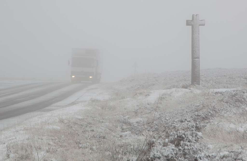
2011 was a very early spring but it's interesting to look at some pictures from about now.
The trees were almost in full leaf - about two weeks ahead of normal - but this year they are now more like two weeks behind.

May 9th 2011 - a different year!


Averages\Extremes for May 2011 ------------------------------------------------------------


Average temperature     = 11.0°C;
 Average humidity        = 77%
 Average dewpoint        = 6.9°C
 Average barometer       = 1014.2 mb
 Average windspeed       = 9.2 mph
 Average gustspeed       = 12.7 mph
 Average direction       = 234° ( SW)
 Rainfall for month      = 39.6 mm
 Rainfall for year       = 186.6 mm
 Maximum rain per minute = 0.8 mm on day 26 at time 13:05
 Maximum temperature     = 20.1°C on day 07 at time 12:44
 Minimum temperature     = -2.7°C on day 04 at time 06:26


Averages\Extremes for May 2012

 Average temperature     = 9.6°C
 Average humidity        = 85%
 Average dewpoint        = 7.0°C
 Average barometer       = 1016.7 mb
 Average windspeed       = 5.2 mph
 Average gustspeed       = 8.0 mph
 Average direction       = 303° (WNW)
 Rainfall for month      = 69.0 mm
 Rainfall for year       = 301.9 mm
 Maximum temperature     = 24.9°C on day 28 at time 15:53
 Minimum temperature     = -4.2°C on day 06 at time 04:11

Saturday 28 April 2012

Wettest April for many years

With the month total now on 151mm and a wet day predicted for tomorrow (Sunday) it is looking like an exceptionally wet month for any season, especially unusual when April is often rather too dry if anything!
Since the station began recording the wettest month was August 2006 with 208mm.
It's unlikely that total will be exceeded in the final two days I hope.

It's also been consistently chilly with highest temperature only 13.7C so far, although Monday 30th could top that.
The average is running at 5.6C which is about 2.5C below the norm for recent years (somewhat skewed by last years very warm April)
March was 7.8C, a good 2C warmer.

Trees and plants were starting to grow rapidly during the warm days at the end of March but progress has slowed to a crawl through this month although perhaps only to a more or less 'normal' stage at present.
Even on chilly days when the sun comes out it is powerful and feels pleasant.
A memorable month but not for the best of reasons!

Monday 23 April 2012

April Rainfall

The last two years have seen exceptionally dry Aprils, but 2012 could hardly be more different.
At the 23rd we are on 112.3mm, there will almost certainly be more through this final week.
The total for January, February and March was only about 68mm so it is likely April will triple the annual total!
The snow in the first week would have not all be counted, so the real total should likely be about 5mm higher.

Going into May it looks rather less rainy but still 'changeable' and certainly no heatwave but perhaps near average or just below.

Tuesday 17 April 2012

More April snow!

Another wet and wintry start to the day this morning, but being April by midday the sun and breeze made it feel like a different day with temperature getting above 10C for the first time since the 12th.


Saturday 14 April 2012

Chilly April

You will have noticed(!) it's been cold, but compared to March the chill is especially striking.
Currently April Average is at 5.7C which is almost 3C below average.
March meanwhile came in at 7.8C which was 1.6C above average!
It's unlikely April will catch up to March now although it does seem like becoming a little less cold as we go into the second half - still rather unsettled though - but with winds tending more to the NW we may miss the worst here in the east.

Incidentally the weather website has been having a minor glitch after a Windows 7 update on the 11th, the software kept stalling.
After tinkering with a few settings to no avail, I have simply uninstalled the Windows updates which I hope will resolve it.
No data is lost but sometimes the site might not update if the program has got stuck.
If that happens it will typically need restarting manually.
Data is then downloaded from the weather station software and everything updates.
Fingers crossed it will be OK again now. Usually it will run for weeks at a time with no attention.

You can see how long it has been continuously running at the bottom of the page - and the data received numbers will increase all the while (it gets a packet about every three seconds).
It is doing quite well if it gets above 500,000, the most so far was just over a million.
Then there was a windows update requiring restart ...

Tuesday 3 April 2012

April snowstorm

It happens depressingly frequently, but the wet snow blizzard 3rd into 4th April will be a serious lamb-killer with many lambs less than a week old being very vulnerable to hypothermia when wet for hours.

Although the forecast was reasonably accurate it was hard to believe it could snow for hours after temperatures of 20C just a few days previously!

Although the blowing snow will not have been accurately recorded as precipitation, the 3rd of April has had more 'rain' than February and March combined.

 Update:
What an extreme event this turned into, estimated 18inches of snow over high ground in little more than 12 hours. Lower down, the sticky snow combined with wind at just above freezing also caused extensive damage to overhead power lines which meant some properties were cut off from late Tuesday until the following Saturday.

Tuesday 27 March 2012

First 21C

Today 27th March we touched 21.9C - over 70°F for the first time.
March can be very variable as this rather poor quality video from 1995 shows

Sunday 25 March 2012

The March warm spell

I'd hesitate to call it a heatwave but today 25th March has reached 18.2C under near perfect blue skies.
What is particularly noteworthy is the prolonged dominance of High Pressure.
If it were July this would have been a memorable summer spell.
Being so early in the year the North Sea is cold and some days have been rather grey.

An increasing worry is the continued lack of significant rain.
February had just 10.8mm (average is 54mm) and March will be stuck on 14.2mm (50mm)
November, December and January also had only around 50% of normal.

At the moment, April seems likely to start rather average which will seem much cooler and there may be some rain.
April is one of the driest months as rule so it will be quite unlikely to make up the deficit, although we may get enough to get spring growth underway.

Wednesday 14 March 2012

March morning mist-ery

The recent spell of High Pressure has produced a few fine spring-like days with maximum temperatures touching 16.4C on the 11th.
When winds die down mist and fog are still always on the cards.

Monday 5 March 2012

Classic March

Blazing sunshine but a chilly wind and icy patches.
The snow fell during yesterday afternoon but was only very slushy at lower levels.

Saturday 4 February 2012

Blowing snow

Short video of today's sub-zero snow falling/blowing.
Winds touched 40mph which is a serious windchill at -2C

Monday 23 January 2012

Undulatus clouds

On Friday the 20th, after a chilly but dry start some sleety rain arrived soon after noon.
The leading edge of the cloud sheet was marked by this curious deeply textured formation.

Tuesday 3 January 2012

Nice timelapse

There seems to be several people competing with each other to do these fantastic timelapse sequences.
Although it soon feels like you saw most things before, every now and then one stands out.

Finding Oregon from Uncage the Soul Productions on Vimeo.

Monday 2 January 2012

Messin' with 7

Tinkering with my old IBM Desktop tower lately -
It originally came with XP and just 256mb of RAM.
When I first set up the online weather station, this old PC had been upgraded to 2GB of RAM and ran continuously for some 18 months running Weather-Display.
I then picked up a cheap netbook which ran the station more economically (and almost silently!) until now.

Anyway since I mainly use a laptop as a main computer these days, the old PC has been little used so with the long winter evenings I decided to see if it could be updated to Windows 7, as I really like that OS on the laptop.
Although the microsoft windows 7 compatibility tool pointed out the graphics card was too old to run Aero fancy desktop effects, it seemed as though it should work OK but might need some 3rd party drivers.

So plucking up courage I moved some old pictures and records stored on it and went for the full Windows 7 clean install.
Plan B if it failed was to set it up with Ubuntu which I had tried before as a dual boot with it (but didn't much like to be honest).

Anyway all went well, and there was only one minor issue in that the sound didn't work until I looked up a new driver for it.
I must say the old thing never started and ran so quickly before when on XP - even though it generally was OK - but prone to briefly hanging if asked to do more than one thing at once.

Being flushed with this success I began to wonder if the XP netbook could also run the Windows 7.
Again the MS tool says should be no problem although it does only have 1GB of RAM this is considered adequate, and could be upgraded to 2GB later if need be.
Since the netbook literally does nothing but run Weather-Display and upload files to the internet, it will probably be fine with 1GB.

So for now, I've transferred the Weather station and software off the netbook and onto the old desktop on Windows 7.
This was surprisingly simple and it's running fine so far, but I'd like to leave it there a couple of days to make sure no stalling occurs before thinking about changing the netbook to Windows 7 too, and moving the station back to there.

Update 5th January:
Netbook install of Windows7 went like a dream and with nothing else installed it uses only 400mb of the 1GB RAM so no problems putting Weather-Display software on it.
It took most of a day to install all the W7 updates though, as you have to do it in stages, with restarting and waiting for installations to complete.