Very short clip of wind on the moors Christmas Eve - to be honest I was just trying the phone video so only wanted a short snippet to play with rendering etc.
This is with windows closed BTW!
Weather topics related to the main weather site - www.weather.westerdale.info
Tuesday, 24 December 2013
Record Low Barometer
Not the sexiest record to break but the low pressure systems currently giving us rinse and repeat storm events have been getting deeper and deeper.
At 1:22am it got down to 961.4mb this morning 24th December.
A long way from the lowest ever recorded though - in 1884
(source Kevin's weather history:
http://forum.netweather.tv/user/1853-weather-history/ )
925.6mb at Ochertyre, near Crieff, Perthshire on the 26th January 1884

Here are some barometer readings of this remarkable depression.
London: barometer fell to 28.529" (966mb) at 7.30pm
Dr Beverly of Aberdeen at 11.30pm recorded a barometer reading at sea level of 27.381" (927.1mb)
Forest of Glen Tana, a reading of 27.39" (927.4mb) was recorded
Hitchin: 28.32" (959mb)
North Shields: 27.63" (936mb)
Cargen: 27.66" (936mb)
Oban: 27.39" (927.4mb)
Dublin: 28.15" (953mb)
Croydon: 28.548" (966mb) at 7.40pm
Worksop: 28.292" (958mb)
Some other weather reports
London: Violent SW gale
Stanmore: Terrific gale from SW to W after 4pm
Reigate: Violent storm with very low pressure
Croydon: Strong gale, max hourly velocity of wind 40 miles
Hythe: From 5.30 to 9.30pm, terrific hurricane, with heavy thunderstorm rain and hail
Littlehampton: Awful gale
St Lawrence: Severe SW gale with vivid lightning
Oundle: Hurricane with heavy rain, snow and lightning
Diss: Tremendous gale from west, thunderstorm in evening
Torquay: Fearful SW gale with rain, thunder and lightning
Coventry: Much lightning, violent wind and unusually low bar
Mansfield: Very violent gale with snow, vivid lightning and thunder
Macclesfield: Gales, snow, rain and lightning
Morpeth: A great gale with very low pressure
Penrith: Great storm with extremely low barometer
Elterwater: Great gale with snow, sleet and rain
Llanfrechfa Grange: Violent SW wind, thunder, lightning and rain
Girvan: Severe storm; pressure fell almost 2.5" very rapidly and rose again almost as quickly.
Cassillis: Storm of extraordinary severity with snow and rain
Keith: About two inches of snow fell with fearful drifts on the following day.
Aviemore: Severe gale from west, highland railway blocked by snow
Forsinard: High winds, snow and drifts
Castle Lough: Great storm with heavy rain followed by snow
Kilconnell: Violent storm from SW, veering to NW
Castlebar: Violent storm follwed by a fall of snow
Enniskillen: A very severe storm with remarkable fall of pressure; old trees which had stood for 130 years were blown down.
Newtownlands: The most terrific storm since 1839, wind 78 miles an hour.
Douglas: Hurricane from 4pm on 26th to 4am on 27th.
These lows are a result of pulses of extreme cold being forced out of North America into the relatively warm North Atlantic.
Each time this occurs deep depression(s) form as a result of teh huge temperature contrast, then the currently very active jet stream pushes them across in a few days.
The pattern shows little sign of changing for a couple of weeks at least.
Furthermore each event is cooling the North Atlantic and we are seeing progressively colder air entrained here - the risk of brief snow events is increasing.
At 1:22am it got down to 961.4mb this morning 24th December.
A long way from the lowest ever recorded though - in 1884
(source Kevin's weather history:
http://forum.netweather.tv/user/1853-weather-history/ )
925.6mb at Ochertyre, near Crieff, Perthshire on the 26th January 1884
Here are some barometer readings of this remarkable depression.
London: barometer fell to 28.529" (966mb) at 7.30pm
Dr Beverly of Aberdeen at 11.30pm recorded a barometer reading at sea level of 27.381" (927.1mb)
Forest of Glen Tana, a reading of 27.39" (927.4mb) was recorded
Hitchin: 28.32" (959mb)
North Shields: 27.63" (936mb)
Cargen: 27.66" (936mb)
Oban: 27.39" (927.4mb)
Dublin: 28.15" (953mb)
Croydon: 28.548" (966mb) at 7.40pm
Worksop: 28.292" (958mb)
Some other weather reports
London: Violent SW gale
Stanmore: Terrific gale from SW to W after 4pm
Reigate: Violent storm with very low pressure
Croydon: Strong gale, max hourly velocity of wind 40 miles
Hythe: From 5.30 to 9.30pm, terrific hurricane, with heavy thunderstorm rain and hail
Littlehampton: Awful gale
St Lawrence: Severe SW gale with vivid lightning
Oundle: Hurricane with heavy rain, snow and lightning
Diss: Tremendous gale from west, thunderstorm in evening
Torquay: Fearful SW gale with rain, thunder and lightning
Coventry: Much lightning, violent wind and unusually low bar
Mansfield: Very violent gale with snow, vivid lightning and thunder
Macclesfield: Gales, snow, rain and lightning
Morpeth: A great gale with very low pressure
Penrith: Great storm with extremely low barometer
Elterwater: Great gale with snow, sleet and rain
Llanfrechfa Grange: Violent SW wind, thunder, lightning and rain
Girvan: Severe storm; pressure fell almost 2.5" very rapidly and rose again almost as quickly.
Cassillis: Storm of extraordinary severity with snow and rain
Keith: About two inches of snow fell with fearful drifts on the following day.
Aviemore: Severe gale from west, highland railway blocked by snow
Forsinard: High winds, snow and drifts
Castle Lough: Great storm with heavy rain followed by snow
Kilconnell: Violent storm from SW, veering to NW
Castlebar: Violent storm follwed by a fall of snow
Enniskillen: A very severe storm with remarkable fall of pressure; old trees which had stood for 130 years were blown down.
Newtownlands: The most terrific storm since 1839, wind 78 miles an hour.
Douglas: Hurricane from 4pm on 26th to 4am on 27th.
These lows are a result of pulses of extreme cold being forced out of North America into the relatively warm North Atlantic.
Each time this occurs deep depression(s) form as a result of teh huge temperature contrast, then the currently very active jet stream pushes them across in a few days.
The pattern shows little sign of changing for a couple of weeks at least.
Furthermore each event is cooling the North Atlantic and we are seeing progressively colder air entrained here - the risk of brief snow events is increasing.
Tuesday, 10 December 2013
Fylingdales Webcam
This will be good in snowy weather.
NYCC mentioned their new cam on Twitter, originally saying it was on the A171 [ooops]
I reminded them which road it was actually on then realised a couple of days later it points south not north as the on screen text says.
Apparently that can't be changed until the next engineer service visit.
Initially it was set facing north but the road spray dirtied the lens quicker (they said, I don't see how it's better looking into the sun TBH)
Edit December 2014:
This camera has been reoved due to problems with the solar power since there is no mains supply.
There are two cameras on Blue Bank not far away.
http://www.northyorks.gov.uk/article/24608/Road-cameras-and-weather-conditions
Thursday, 5 December 2013
Thursday, 28 November 2013
Fall Streak Hole
This was yesterday the 27th November, in fact there were several others visible to the south too.
You can see air from above the cloud layer literally falling through - almost like a fog waterfall - and forming a tail of misty cloud as water vapour condenses out.


You can see air from above the cloud layer literally falling through - almost like a fog waterfall - and forming a tail of misty cloud as water vapour condenses out.


Sunday, 10 November 2013
A complete wunderground timelapse!
After uploading stills for about two months, here is one I an quite pleased with, in particular it caught the moon and a little shower at dusk on the 9th November.
Sunday, 22 September 2013

Thursday, 12 September 2013
Last 24 hour video
Webcam is currently on Wunderground and they do this timelapse - but it seems a bit jumpy so far.
I think the automated checker is confused by the completely dark overnight for one thing.
Update/edit - disappointed with this, no idea why they find it so hard top save an image every 5 minutes but the timelapse made 48 hours into one 'day' then has not updated!
I sent a message to support but no-one answered and frankly it's a bit pants anyway.
(as are wunderground altogether, since being taken over by weather channel)
Monday, 9 September 2013
Rain event 6th September 2013
Here we had 52.2mm, Loftus recorded 44mm but Redcar had 68mm as there was a further heavy period of rain in the evening there.
Thursday, 18 July 2013
Hot!
Well, very warm.
Two days have touched 26.9C which is hardly record breaking - but such a change compared to recent years especially 2012!
So far 14 days with no rain recorded which is a station record and perhaps will soon become something of a concern.
While the good weather has been ideal for hay-making, grazing is fading fast especially on banksides.
There are signs of a breakdown which may be rather thundery from as early as Wednesday next week - however some models build high pressure back again quite rapidly.
Monday, 10 June 2013
European weather
While usually this blog confines posts to local conditions and events, it has been a very strange spring through Europe - and parts of North America at least have been cold later than normal too.
The exceptional rainfall has caused severe flooding especially in Southern Germany and adjacent areas.
This has been caused by a very 'stuck' system funneling rain and cool winds from the north into conflict with moisture laden warmth from the south.
The pattern is not unusual, but the persistence and intensity of precipitation has been exceptional.
Meanwhile the same system has brought unheard of late snowfalls to The Alps, Pyrennees and even southern Spain.
Good link here:
http://www.planetski.eu/news/5022
Meanwhile we have been on the northern side of the jetstream in a chilly but sunny anticyclone.
Temperatures to 10th of June have continued the theme of recent months at some 2C below average, but it has been very dry especially compared to June last year - which by now was above 60mm compared to 0.2mm this year!
There is still not much to suggest a big change, but the next few days will be less settled, with some rain likely, and we will lose the onshore winds so temperatures may creep to more like average with less of the chilly nights.
Wednesday, 29 May 2013
Web cam
Just trying something out here, I bought a couple of IP cams cheaply on ebay but one of them had an intermittent problem in that when the overnight IR lights were on it would conk out after an hour - not sure if it overheated or what.
While in theory I could have returned it, since it was basically working I ended up investigating the internals and then after a bit of thinking time I de-activated the IR lights by bypassing the light level sensor (by soldering a link across the terminals).
This means it can be used through glass without reflection issues so I'm considering using it as a weather webcam.
The image quality is not that good though, and to avoid overloading the ftp connection I'm just uploading a jpg image every 5 minutes rather than proper streaming.
I'll probably use a different view to this if things run OK for a few days.
Here's the trial page and latest uploaded image below
http://weather.westerdale.info/cam/
I'll probably use a different view to this if things run OK for a few days.
Here's the trial page and latest uploaded image below
http://weather.westerdale.info/cam/
 |
| updates every 5 minutes |
Saturday, 27 April 2013
Late April snow
Hail and west snow gave a brief cover this morning, 27th April.
Even the nearest field was white briefly.

Wednesday, 10 April 2013
Yo Window update
I noticed this had stopped updating so installed the latest version which has subtle changes.
ScreenSaver
Forecast by yr.no
Thursday, 4 April 2013
March figures
A month rivaling December 2010 in how far the temperature deviated from the mean.
http://weather.westerdale.info/climatedataout32013.html
The first week was not unusual but around the 10th some very cold air arrived from the east and is more or less still with us 1st week of April.
The second half of March is probably the coldest such period in at least 100 years (1892 may have beat it)
March and indeed April will often have a few snowy days often associated with a brief Northerly.
This period has been quite different with a long fetch easterly bringing exceptional cold air for the time of year across most of Europe.
Germany for example has also been extremely cold.
Paul Hudson now says it has been the coldest March since 1892
http://www.bbc.co.uk/blogs/paulhudson/posts/Latest-weather-climate-news
Thursday, 21 March 2013
Cold March
With wintry weather likely to dominate until at least the last day or two, this will be the coldest March for many years - probably since 1979.
At the moment the mean is running at about 2.2C which is 3.5C below normal.
It's also below January's mean, which is unusual considering that month was near average. March is noted for having cold and snowy events and they can be as severe as anything through winter - but usually they are short-lived affairs and the most characteristic weather type is drying winds often from a rather chilly North Westerly direction.
Apart from 4 or 5 almost dry breezy days near the start, this March has been very disappointing.
On balance, good weather in April might be preferred over what happened last year with a pleasant March then a cold, wintry wet April!
Paul Hudson suggests it will be the coldest since 1969.
http://www.bbc.co.uk/blogs/paulhudson/posts/More-snow-as-March-set-to-be-coldest-since1969
Friday, 1 March 2013
Timelapse
I did this a few days ago after buying a cheap intervalometer for the SLR.
In the past I did the easier 'timelapse' technique of simply speeding up video in moviemaker, but this is 300 jpg stills at one second intervals, combined into a very fast slideshow.
I found some free software which has the ability to pan and zoom in the frame if I ever work out how to do it!
Anyway for a first go it worked OK and it would be nice to get some moving skyscapes through the year.
Saturday, 16 February 2013
Drier but chilly
Fairly typical February weather coming up with a slack easterly flow and fairly dry - but some light wintry showers from the sea at times.
The snowdrifts will be here a while yet.

Monday, 11 February 2013
Microsoft blog writer
Having just downloaded the windows live package to update moviemaker, I thought I would try the blog writing tool also.
Setting up seems fairly easy anyway but it will need a few experimental posts like this to decide if it is better than logging in to blogger.
Wednesday, 30 January 2013
Snowdrift survival
Despite temperatures well above 10°C yesterday the snowdrifts show every sign of being around for a few weeks yet!


Tuesday, 29 January 2013
Rapid thaw
Although there was a sudden change on Sunday and a lot of green re-appeared in the space of 24 hours, it was never exactly 'mild' - but this afternoon we touched 11.8C for a couple of hours which is quite impressive for the coldest point of the year late January.
Even over the moor tops the old drifts were pouring away.
However by mid-evening temperature was falling away again so only a brief interlude.
Since it was blowing a gale and drizzly it was hardly pleasant.
Even over the moor tops the old drifts were pouring away.
However by mid-evening temperature was falling away again so only a brief interlude.
Since it was blowing a gale and drizzly it was hardly pleasant.
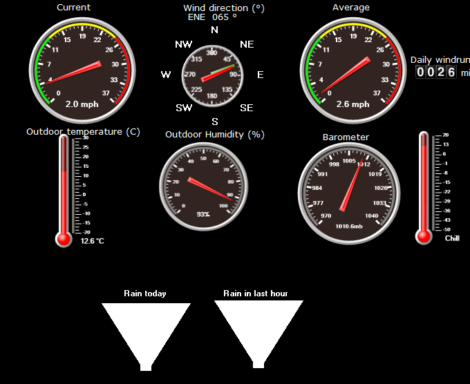
New dials page
To be honest I was never that impressed withe the Weather Display dials - it seems quite hard to read some of the elements, however I've made a new page with them on.
You can still see the current temperature clearly in the top bar.
The odometer on the right shows the current day's windrun - but it only updates every 5 minutes.
The odometer on the right shows the current day's windrun - but it only updates every 5 minutes.
It's a pity it doesn't kind of click up continuously!
I've noticed the image is often 5 minutes behind for some reason.
Perhaps this is due to rather slow internet mid-evening just now.
I've noticed the image is often 5 minutes behind for some reason.
Perhaps this is due to rather slow internet mid-evening just now.
And here they are live:
Friday, 25 January 2013
Drifting Snow
There are times when the North York Moors seems notorious for this.
This morning the wind was sweeping straight down from Ralphs Cross at -1.5C
Little snow was actually falling.
Friday, 18 January 2013
Thursday, 17 January 2013

Tuesday, 15 January 2013
It's cold
With deep snow falling over the last couple of days, when the wind dropped out under clear skies temperatures plummeted after sunset to -10.6C this morning.
This is the lowest since December 2010 when we touched -12.3C


Subscribe to:
Posts (Atom)